- PUBLISHED
Top Himalayan Peaks Visible During the Everest Base Camp Trek
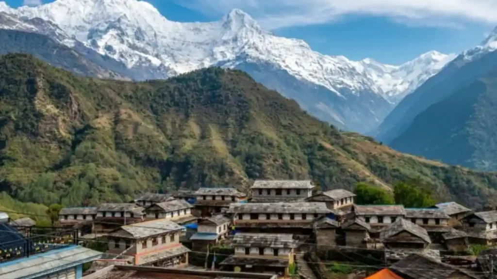
Few adventures in the world rival trekking to Everest Base Camp (EBC), a journey that blends breathtaking Himalayan scenery, Sherpa culture, and the thrill of standing near the world’s tallest peaks. From the moment you arrive in Lukla and begin ascending through forests, rivers, and Sherpa villages, the Khumbu region gradually unfolds, revealing panoramic views of glaciers, deep valleys, and snow-capped giants. Along the way, trekkers are treated to views from base camp Everest that leave a lasting impression.
For those interested in peak climbing in Nepal, the Everest region offers some of the most iconic and challenging ascents worldwide. Whether you are a first-time trekker curious about where Mount Everest Base Camp is or a photographer seeking the perfect Himalayan shot, this guide provides everything you need. From the top Himalayan peaks to the best viewpoints, photography tips, and FAQs, you will be fully prepared for an unforgettable journey.
Overview of the Himalayas: A Detailed Look at the Everest Region
The Himalayas are far more than just a mountain range; they are the spine of Asia, stretching over 1,500 miles across five countries: Nepal, India, Bhutan, Tibet, and Pakistan. Home to all 14 of the world’s peaks above 8,000 meters, including Mount Everest, the Himalayas are the epitome of natural grandeur. These mountains were formed millions of years ago when the Indian tectonic plate collided with the Eurasian plate, a process that continues to lift the peaks even today.
Nepal’s Himalayan region is ecologically and culturally diverse, divided into three main zones:
- Lower Hills: Lush forests, terraced farmland, and vibrant villages.
- Mid-Hills: Winding rivers, steep passes, and early glimpses of snow-capped peaks.
- High Mountains: Alpine zones, glaciers, rocky ridges, and peaks towering above 6,000 meters.
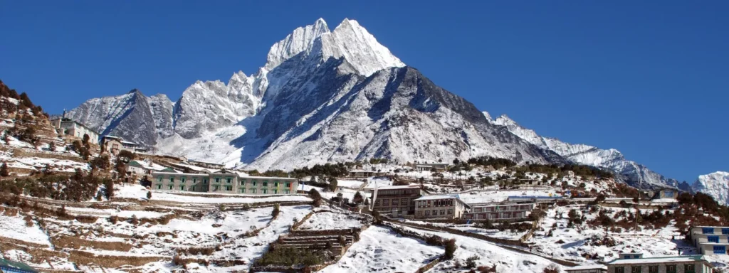
The Everest region, also called Sagarmatha National Park, is a UNESCO World Heritage site. Covering over 1,100 square kilometers, it is rich in biodiversity and home to rare species such as snow leopards, red pandas, Himalayan tahr, and dozens of bird species. Glacial rivers carve deep valleys, creating dramatic landscapes that challenge trekkers and reward them with awe-inspiring vistas.
Culturally, the region is predominantly inhabited by the Sherpa people, who are renowned worldwide for their mountaineering expertise. Villages like Namche Bazaar, Tengboche, and Dingboche offer trekkers an intimate glimpse into Sherpa life. Prayer flags flutter in the wind, monasteries provide a spiritual backdrop, and mani stones line the paths, creating a trail that is as much about culture as it is about adventure. Learning how to prepare for mountain climbing in this environment is key to enjoying the trek safely.
Trekking in the Himalayas is thus not just a physical endeavor; it is a journey of discovery. Every mountain has a story, every valley a history, and every village a unique cultural narrative. As you move higher toward Everest Base Camp, the peaks become not just scenery, but companions on a transformative adventure. Understanding the Everest Base Camp elevation helps trekkers plan acclimatization properly, avoiding altitude sickness while enjoying the journey.
Top 10 Himalayan Peaks Visible During the Everest Base Camp Trek
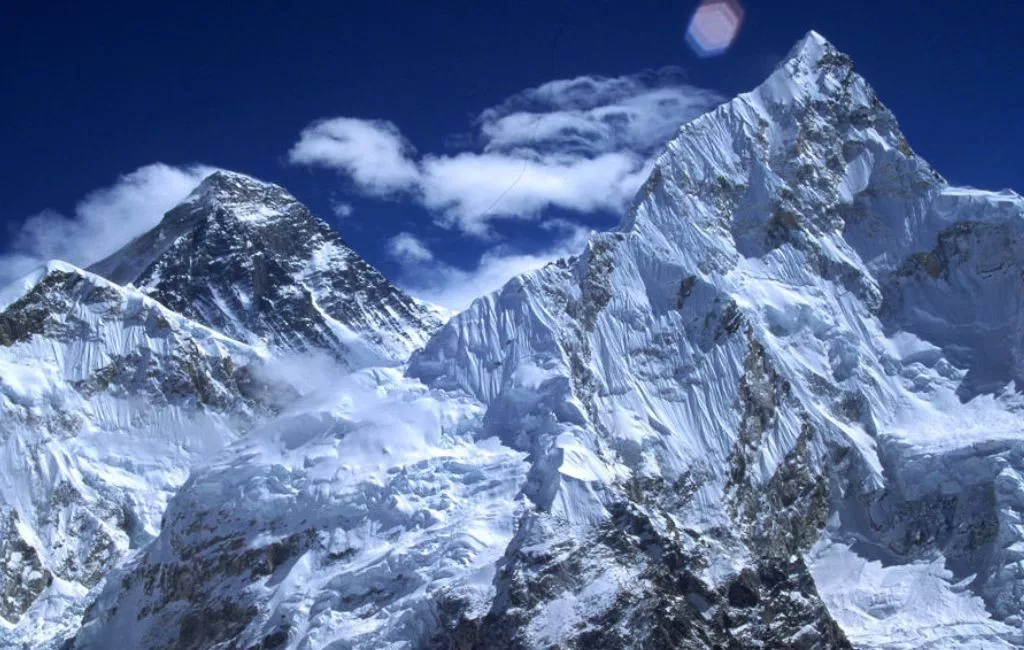
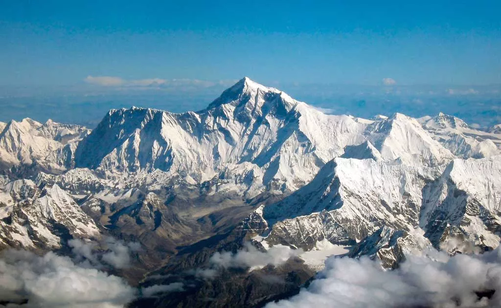
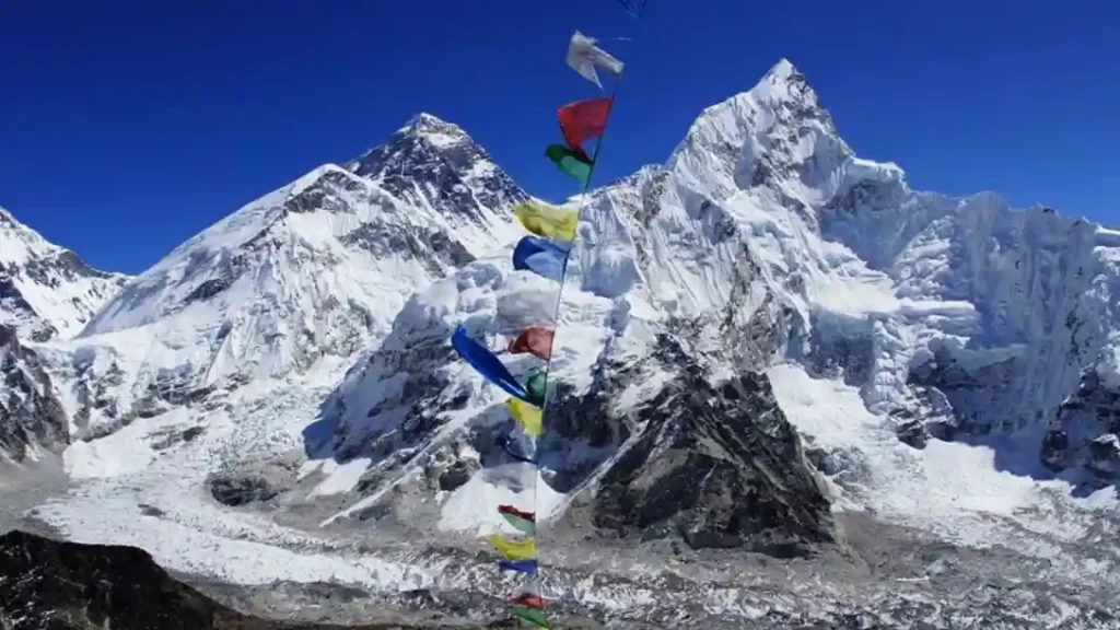
1. Mount Everest
Height: 8,848 meters (29,029 feet)
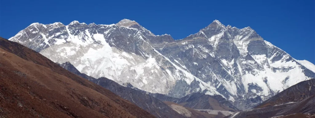
Overview: Known locally as Sagarmatha, Mount Everest is the tallest peak on Earth and the crown jewel of the Himalayas. Its massive snow-covered slopes dominate the Khumbu region and inspire awe in every trekker. Seeing Mount Everest from base camp is a dream come true for adventurers worldwide. The mountain’s presence is gradually revealed along the trek, from distant outlines at Namche Bazaar to full frontal glory at Kala Patthar.
Trekking Experience: The trek to Everest Base Camp is carefully staged to allow trekkers to acclimatize while gradually approaching the mountain. Early in the journey, Everest appears as a distant silhouette. By the time trekkers reach Gorak Shep and Kala Patthar, the full scale and majesty of Everest becomes apparent. Sunrises on Everest, when the first golden rays illuminate its peak, are particularly breathtaking and make for unforgettable photography.
Cultural Significance: Everest holds deep spiritual meaning for the Sherpa people. It is revered as Sagarmatha, meaning “Forehead of the Sky,” and the area surrounding the base camp is sprinkled with prayer flags, stupas, and small shrines, reminding trekkers of the intertwining of adventure and spirituality.
Best Viewpoints:
- Kala Patthar: Offers the most famous panoramic sunrise and sunset views.
- Gorak Shep: Up-close views near the last settlement before base camp.
- Lobuche: Provides distant yet dramatic perspectives during the ascent.
Fun Fact: Everest’s summit continues to rise about 4 millimeters per year due to tectonic activity.

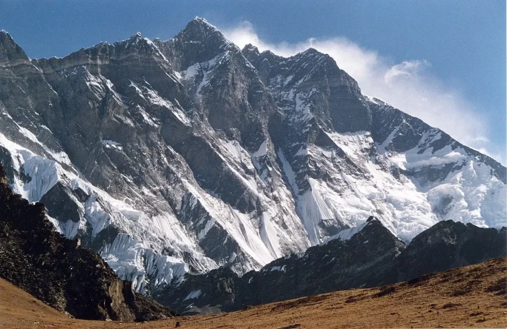
2. Lhotse
Height: 8,516 meters (27,940 feet)
Overview: Lhotse is the fourth-highest mountain in the world and sits directly south of Everest. Known for its massive south face and towering cliffs, Lhotse often appears overshadowed by Everest but is a spectacle in its own right. Its enormous presence dominates the view as trekkers ascend toward Gorak Shep and Kala Patthar.
Trekking Experience: Lhotse is particularly striking when seen at sunrise or sunset, as the sunlight casts long shadows on its jagged ridges. The mountain offers photographers incredible opportunities, especially when framed alongside Everest and Nuptse. Many trekkers marvel at its scale and icy faces while resting at Gorak Shep or trekking toward the base camp.
Cultural Significance: Often considered Everest’s companion, Lhotse is revered as part of the sacred massif. Sherpas have deep respect for its slopes, and the mountain is interwoven with local legends and spiritual beliefs.
Best Viewpoints:
- Gorak Shep trail: Direct views of Lhotse’s south face.
- Kala Patthar: Dramatic panoramas with Everest and Nuptse in the same frame.
Fun Fact: Lhotse’s south face is one of the steepest in the world and is considered a highly challenging climb for mountaineers.
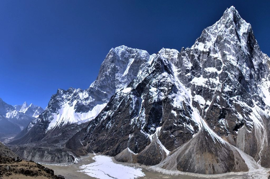
3. Nuptse
Height: 7,861 meters (25,791 feet)
Overview: Southwest of Everest lies Nuptse, a peak famous for its jagged ridges and rugged profile. Its sharp edges and rocky slopes stand in striking contrast to the smoother lines of Everest and Lhotse, making it a visually captivating addition to the Himalayan skyline.
Trekking Experience: Nuptse becomes particularly visible as trekkers approach Gorak Shep and Kala Patthar. Its dramatic silhouette provides an ever-changing backdrop for photography, especially during sunrise when shadows create depth and texture on the ridges.
Cultural Significance: Although Nuptse is less frequently climbed than Everest, it is respected by locals for its formidable terrain and the natural beauty it adds to the region.
Best Viewpoints:
- Kala Patthar: Offers unobstructed views along with Everest and Lhotse.
- Gorak Shep trail: Ideal for capturing its jagged peaks close-up.
Fun Fact: Nuptse means “West Peak,” reflecting its position relative to Everest.
4. Ama Dablam
Height: 6,812 meters (22,349 feet)
Overview: Ama Dablam is often called the “Matterhorn of the Himalayas” for its elegant spire-like summit and hanging glaciers. Its unique shape and striking profile make it one of the most photographed mountains in Nepal.
Trekking Experience: Ama Dablam can be admired from multiple villages along the trail, including Pangboche, Dingboche, and Tengboche. Its steep faces and glaciers create dramatic photo opportunities, especially at sunrise and sunset.
Cultural Significance: The mountain’s name translates to “Mother’s Necklace,” referring to a hanging glacier that resembles jewelry. Ama Dablam is sacred to the Sherpas, and prayer flags flutter across its slopes, adding a spiritual dimension to the views.
Best Viewpoints:
- Tengboche Monastery: Combines cultural ambiance with a majestic mountain backdrop.
- Dingboche & Pangboche villages: Mid-elevation points for closer observation.
Fun Fact: Ama Dablam was first climbed in 1961 by a New Zealand expedition team.
5. Thamserku
Height: 6,623 meters (21,729 feet)
Overview: Thamserku rises east of Namche Bazaar and is known for its pyramidal shape. Though not as famous as Everest or Ama Dablam, it offers trekkers one of the first dramatic peaks in the higher Khumbu region. Its rugged terrain and prominent ridges are visible for much of the trek, especially from Namche Bazaar and Tengboche.
Trekking Experience: Trekkers get their first real Himalayan “wow moment” when Thamserku comes into view. The peak’s sharp ridges and snow-covered slopes make it a favorite subject for photography. Sunrise casts golden light on the peak, creating spectacular contrasts against the valley below.
Cultural Significance: Thamserku holds spiritual importance to local Sherpa communities and is often featured in local folklore.
Best Viewpoints:
- Namche Bazaar: Offers panoramic views as trekkers ascend toward Tengboche.
- Tengboche Monastery: Provides cultural and visual framing with Thamserku in the background.
Fun Fact: The first ascent of Thamserku was completed in 1964, and it remains a popular peak for climbers seeking technical challenges.
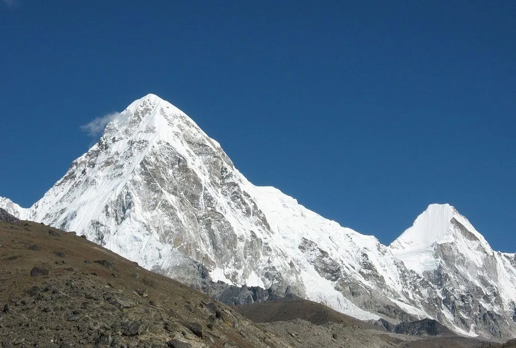
6. Pumori
Height: 7,161 meters (23,494 feet)
Overview: Often called “Everest’s daughter” due to its proximity, Pumori is one of the most striking peaks visible during the EBC trek. Its snow-draped slopes and sharp ridges create a stunning visual contrast to the towering Everest and the rugged Nuptse. The mountain’s prominence along the trek makes it a favorite subject for photographers, especially when framed alongside the Khumbu Icefall and surrounding glaciers.
Trekking Experience: Pumori is visible from Kala Patthar, Gorak Shep, and even Lobuche. Trekkers can witness its changing appearance throughout the day from soft pastel shades at sunrise to sharp contrasts in midday light, and finally, warm golden tones at sunset. Its dramatic ridges are particularly eye-catching when trekkers are resting at Gorak Shep or moving along the moraine paths to EBC.
Cultural Significance: Like many Himalayan peaks, Pumori is revered by local Sherpas. Its slopes are sprinkled with prayer flags, and the mountain is often included in spiritual rituals and festivals of the Khumbu region.
Best Viewpoints:
- Kala Patthar: Offers breathtaking panoramic shots including Everest, Nuptse, and Pumori.
- Gorak Shep trail: Close-up perspectives for photographers and trekkers.
- Lobuche: Ideal for capturing the full Khumbu skyline with Pumori in context.
Fun Fact: Pumori was first climbed in 1962 by a German expedition team. Its name is said to mean “Young Peak” in the Sherpa language.
7. Kangtega
Height: 6,782 meters (22,251 feet)
Overview: Known as the “Snow Saddle,” Kangtega is a distinctive peak northeast of Namche Bazaar. Its twin summits, connected by a glacial saddle, create one of the most recognizable features in the Everest region. Kangtega is less famous than Everest or Ama Dablam but offers trekkers a chance to admire a uniquely shaped mountain that adds variety and depth to the landscape.
Trekking Experience: Kangtega is visible from Dingboche, Pangboche, and parts of the trail approaching Tengboche. Its slopes are framed beautifully by forests, monasteries, and valleys, making it a favorite for photography. Trekkers enjoy watching the peak change colors throughout the day, with early morning light often casting soft pinks and oranges across its snow-covered ridges.
Cultural Significance: Sherpas consider Kangtega sacred, and the peak features in local folklore and oral histories. Its name, meaning “Snow Saddle,” refers to the glacial pass that connects its twin summits.
Best Viewpoints:
- Dingboche village: Provides close and dramatic views.
- Pangboche: Combines mountain scenery with cultural village elements for perfect photo compositions.
- Tengboche Monastery: Offers a spiritual backdrop with Kangtega in the distance.
Fun Fact: Kangtega is often used as a training ground for climbers attempting more technical Himalayan peaks.
8. Taboche
Height: 6,495 meters (21,312 feet)
Overview: Taboche rises near Dingboche and Pheriche, presenting trekkers with a rugged and dramatic peak along the EBC route. Its steep, glacier-covered slopes and jagged ridges are both beautiful and imposing, contributing to the spectacular skyline of the Khumbu region.
Trekking Experience: Taboche is prominently visible from Dingboche and the trail toward Lobuche. Trekkers often pause to admire its sharp ridges, which appear even more dramatic against the softer, rolling valleys below. Sunrise and sunset create stunning contrasts that bring out the mountain’s intricate textures and icy slopes.
Cultural Significance: While not as culturally prominent as Ama Dablam or Everest, Taboche is revered locally for its natural majesty. Sherpa villagers respect the mountain, and its presence is often featured in storytelling and spiritual observances.
Best Viewpoints:
- Dingboche village: Offers close and clear perspectives of Taboche.
- Trail sections above Pangboche: Ideal for panoramic photography.
- Lobuche: Adds depth to the skyline when combined with other peaks in photographs.
Fun Fact: Taboche is considered a technical peak for mountaineers, providing challenging routes without the crowds of Everest or Lhotse.
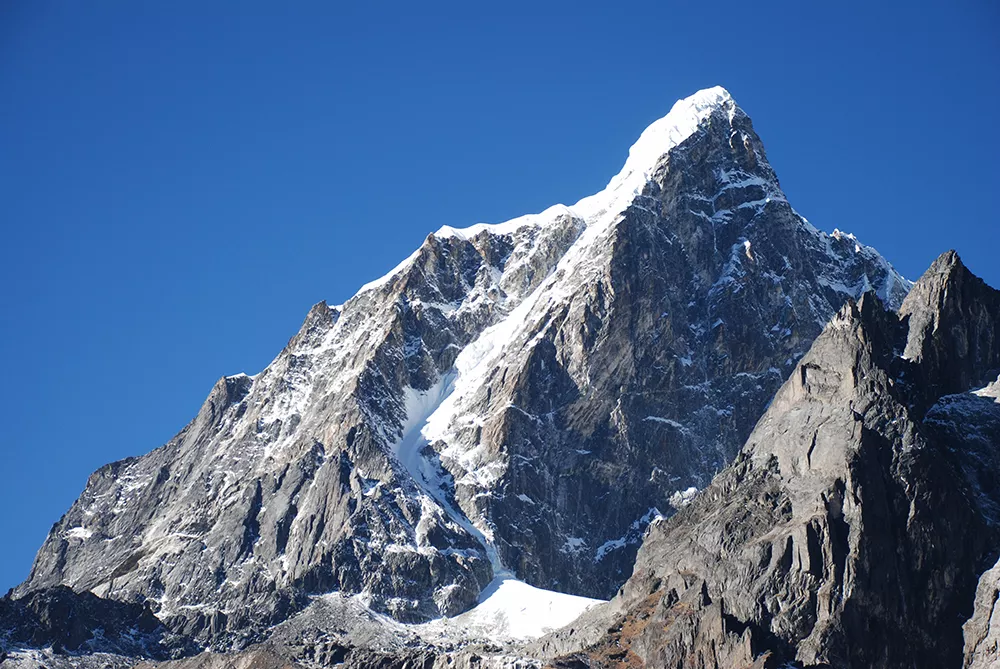
9. Cholatse
Height: 6,440 meters (21,126 feet)
Overview: Cholatse is a striking peak that stands out due to its sharp, spire-like summit and dramatic ridges. Though less famous than Everest or Ama Dablam, it contributes significantly to the Himalayan panorama visible from higher sections of the EBC trek. Its icy slopes, jagged faces, and surrounding glaciers create a visual spectacle for trekkers.
Trekking Experience: Cholatse can be observed from trails approaching Dingboche and Lobuche, as well as from Kala Patthar on clear days. Photographers love capturing Cholatse with Everest and Nuptse in the same frame, as it adds layers of depth and complexity to compositions. The peak is especially dramatic in early morning or late afternoon light, when shadows highlight its steep faces.
Cultural Significance: Cholatse is named in the local Sherpa language as “Yellow Mountain,” and is respected for its natural beauty and challenging slopes. Local folklore often references the peak as a symbol of endurance and strength.
Best Viewpoints:
- Kala Patthar: Panoramic views with Everest, Nuptse, and Pumori.
- Trail near Lobuche: Excellent for capturing Cholatse in context with surrounding peaks.
Fun Fact: Cholatse is a preferred practice peak for climbers preparing for higher technical ascents in the region.
10. Surrounding Minor Peaks of the Khumbu Region
Overview: In addition to the major peaks, trekkers are surrounded by dozens of smaller but impressive mountains such as Cho La peaks, Amphu Lapcha, and other glaciated ridges. These peaks may not have the fame of Everest or Ama Dablam, but they enrich the trekking experience, offering variety and unexpected viewpoints along the trail.
Trekking Experience: Trekkers encounter these peaks constantly from villages like Namche Bazaar, Tengboche, and Dingboche. Each trail bend reveals a new composition: snow-capped ridges, icefalls, and smaller peaks creating layers of depth against the sky. These mountains are perfect for photographers seeking dramatic yet lesser-known Himalayan landscapes.
Cultural Significance: Many of these minor peaks are considered sacred by Sherpas and feature in local rituals and folklore. Prayer flags often mark their slopes, reminding trekkers of the spiritual dimension of the mountains.
Best Viewpoints:
- Kala Patthar: Panoramic shots capturing Everest, Nuptse, and the smaller peaks.
- Dingboche & Tengboche: Scenic and cultural framing of minor peaks.
- Trail sections above Pangboche: Ideal for layered compositions with multiple peaks in view.
Fun Fact: While these minor peaks are less frequently climbed, they are crucial for the overall visual grandeur of the Everest region, creating the layered Himalayan landscapes that trekkers fall in love with.
Photography Tips and Best Time to Visit for Stunning Views
The Everest Base Camp trek is a photographer’s paradise. With snow-capped peaks, glacial valleys, pristine rivers, and traditional Sherpa villages, every step offers opportunities for incredible shots. Planning around the best time to visit Nepal ensures clear skies, vibrant landscapes, and ideal trekking conditions.
1. Golden Hours Are Key
- Sunrise: The early morning light bathes peaks like Everest, Lhotse, Nuptse, and Ama Dablam in soft gold and pink hues.
- Sunset: The last light of day highlights the texture of glaciers and ridges, creating dramatic shadows and contrast.
Tip: Kala Patthar is the ultimate sunrise viewpoint. Plan to hike up before dawn for unobstructed views.
2. Clear Skies Matter
Visibility in the Himalayas can be unpredictable. Monsoon months (June–August) bring heavy clouds and rain, often obscuring views. The best months for clear skies are:
- Pre-monsoon (March–May): Bright days with blooming rhododendrons along the trail.
- Post-monsoon (September–November): Crisp, dry air and clear mountain vistas, ideal for photography.
3. Composition Tips
- Include foreground elements such as prayer flags, mani stones, or villages to give depth and scale.
- Use layers: capture multiple peaks in one shot to convey the grandeur of the Himalayas.
- Wide-angle lenses work best for panoramic shots of Everest and surrounding peaks, while zoom lenses capture distant details on ridges and glaciers.
4. Equipment Essentials
- Camera: DSLR or mirrorless with a wide-angle lens recommended.
- Tripod: Essential for sunrise/sunset shots or long exposures.
- Filters: Polarizing filters help reduce glare from snow and ice.
- Extra batteries: Cold temperatures drain battery life quickly, so carry spares.
By following these tips, your photos won’t just capture mountains; they’ll tell the story of your Himalayan journey.
Conclusion: Your Himalayan Adventure Awaits
The Everest Base Camp trek is an unforgettable adventure that offers breathtaking views of Mount Everest, Lhotse, Nuptse, Ama Dablam, and other iconic Himalayan peaks. Along the way, trekkers experience Sherpa culture, monasteries, and the unique landscapes of the Khumbu region, from forests and rivers to glaciers and high mountain passes. With the right planning, understanding the Everest Base Camp elevation, and following guidance from the BeThere Mountaineering Expert guide, this journey is both safe and transformative.
Whether you are capturing panoramic photographs, exploring cultural villages, or marveling at the sheer scale of the Himalayas, the trek leaves lasting memories. For any questions or personalized advice to prepare for your trek, don’t hesitate to contact BeThere and begin your Himalayan adventure today.
Table of Content
Frequently Asked Questions
Can you see Mount Everest from base camp?
Yes! Mount Everest is clearly visible from Everest Base Camp. From EBC itself, trekkers get close-up views of the south face, the Khumbu Icefall, and the surrounding ridges. For the best views of the summit, trekkers often hike a short distance to Kala Patthar, which provides a panoramic perspective of Everest along with neighboring peaks like Lhotse, Nuptse, and Pumori. Visibility depends on the weather, so clear days in spring (March–May) and autumn (September–November) are ideal.
Is Everest Peak visible from base camp?
Yes, the Everest peak itself is visible, although it may sometimes be partially obscured by clouds. While Base Camp provides a closer look at Everest’s lower slopes, Kala Patthar is the best vantage point for photographing the summit. Trekkers describe the view as life-changing. Seeing the highest point on Earth from a few kilometers away gives a unique sense of scale and awe.
How hard is it to climb Mount Everest?
Climbing Mount Everest is extremely challenging and requires advanced mountaineering skills, technical equipment, and careful acclimatization. While trekking to Everest Base Camp is non-technical and achievable for fit hikers, summiting Everest involves:
Navigating the Khumbu Icefall
Crossing exposed ridges in extreme weather
Dealing with altitude above 8,000 meters (the “death zone”)
Managing risks like avalanches, crevasses, and extreme cold
Most climbers spend 6–10 weeks on expeditions to summit successfully. It is considered one of the hardest climbs in the world, demanding both physical and mental endurance.
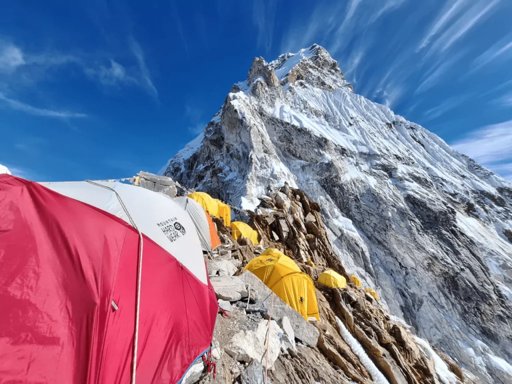
How high is Everest Base Camp?
Everest Base Camp is located at an altitude of 5,364 meters (17,598 feet) on the south side in Nepal. This is where climbers prepare for their summit attempts. Trekkers experience some of the highest elevations without needing technical climbing gear, but acclimatization is crucial to avoid altitude sickness.
What is the elevation difference between Base Camp and the Everest summit?
Mount Everest rises to 8,848 meters (29,029 feet), making the elevation difference from Base Camp about 3,484 meters (11,431 feet). While Base Camp provides stunning views and a sense of Everest’s scale, summiting requires specialized climbing skills and months of preparation.
Can you see Mount Everest from base camp?
Yes! From Everest Base Camp and nearby viewpoints like Kala Patthar, trekkers get clear, close-up views of Everest’s south face. While the peak may be partially obscured by clouds at times, the view is consistently spectacular throughout the trekking season.
How many peaks can you see from Everest Base Camp?
From the EBC trek, trekkers can see dozens of peaks, ranging from iconic giants like Everest, Lhotse, Nuptse, and Ama Dablam to smaller surrounding peaks like Thamserku, Pumori, and Taboche. On clear days, the panoramic views stretch across the Khumbu region, offering a layered mountain landscape unmatched anywhere in the world.
Where is Mount Everest Base Camp?
Everest Base Camp is located in the Khumbu region of Nepal, at an altitude of approximately 5,364 meters (17,598 feet). It serves as the staging point for climbers attempting to summit Everest via the south route. Trekkers follow a trail from Lukla, passing through Sherpa villages and monasteries along the way.
When is the best time to visit EBC for the clearest mountain views?
- Spring (March–May): Blooming rhododendrons and generally clear skies.
- Autumn (September–November): Crisp, dry air with excellent visibility and stable weather.
Is the Everest Base Camp trek suitable for beginners?
Yes, the trek is challenging but non-technical. Proper acclimatization, fitness, and preparation are essential. Most trekkers complete the journey without technical climbing experience, enjoying the views and local culture along the way.

Recent Blogs
Need help choosing a trail?
Connect with a local and plan your perfect trek.